Tropical Forests
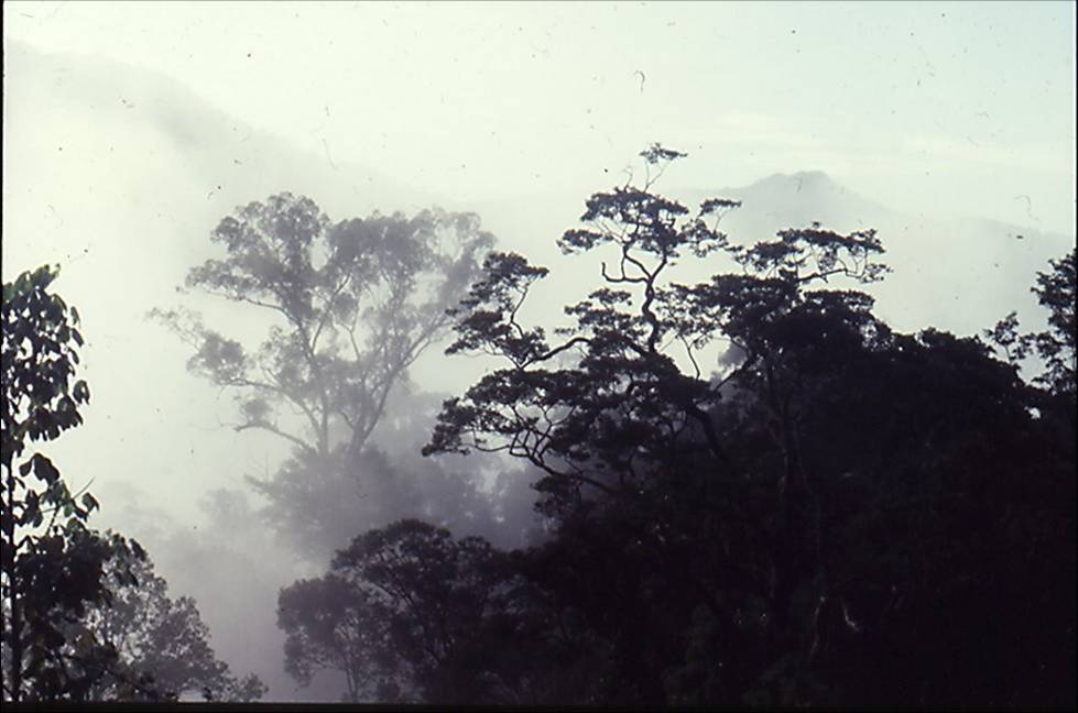
Before - Primary (undisturbed) rain forest - Temburong, Brunei
Hot moist tropical forest, tropical rainforest, is one of the world’s major biomes. It is a woodland characterised by lush vegetation, formed by evergreen broad-leaved tree species where the vegetation is layered: emergent trees, a canopy layer, understorey vegetation and ground vegetation. Its primary criterion is that it is ever-wet or perhumid (Whitmore, 1990) with lack of a strong annual water shortage. It is a lowland vegetation (mainly below 600m), found in a narrow band either side of the equator in both the Old and New Worlds where there are comparatively high temperatures and >3000mm of rainfall in total, more or less equally distributed throughout the year. Globally only three large bocks of tropical rainforests remain: the neotropical forests mainly in S. America, equatorial Africa (especially W.) and SE Asia extending into northern Australasia. Although they cover less than two percent of the earth’s surface, they are the most productive, most complex and most biologically diverse ecosystems on earth, being home to some 50-70% of all life forms on our planet (including most of the thyridid and pyralid moths).
In Borneo tropical lowland evergreen rainforest, (mixed dipterocarp forest) extends from sea level to around 600m. Most has been cleared for agriculture or has been logged except in inaccessible areas or national parks. After heavy disturbance, where agriculture (including plantations) is not practised, the original dipterocarp type of forest will only reappear if seed trees are nearby. In the primary forest tree species are extremely diverse with nearly 1200 spp. recorded in a 52ha plot in NE Sarawak (Lee et al., 2002). Species of the family Dipterocarpaceae dominate. Tropical conifers are uncommon. There are numerous epiphytes, climbers and vines. Disturbed areas and tree gaps often contain Euphorbiaceae, especially Macaranga spp. At least 14 different types of tropical ‘rainforest’ ecosystem have been described, divided into sub-categories according to wetness, altitude or soil fertility (Whitmore, 1990). They are a distinct suite of vegetational communities corresponding to a climatic region, but in SE Asia the principal division is found between the moist tropical forests (broadleaved, evergreen forests dominated by the hardwood trees of the family Dipterocarpaceae centered on Malesia) and seasonally dry (or monsoon) forest found in adjacent regions where dipterocarps are less common and deciduous tree species are more common.
.jpg)
After - highly disturbed rain forest
The maximum geographic extent of tropical vegetation was towards the end of the Cretaceous period (146 >65.5 my bp). By this time most modern groups of plant species had evolved. It was during this extremely warm epoch that the first lepidoptera appeared and moist tropical forest on low ground in some places extended to 50 N, within 4500km of the poles. Subsequent continental redistribution coupled with the possible effects of a meteor impact resulted in climatic cooling and the contraction of tropical forests towards the equatorial regions. More recently, as well as further restricting suitable climatic zones and altitudinal zones, the Pleistocene ice ages caused changes in sea level. The Devensian glaciation, the most recent glacial period, which started approximately 73,000 years before present and ended 10,000 years ago, probably reduced sea levels by 250m and in Malesia this paradoxically provided far larger areas for forest colonisation than were lost by the concomitant lowering of the tree-line. Currently this is at c. 4000m at the equator, higher than all Bornean mountains except the very summit of Mt. Kinabalu. The maximum northern and southern limits of moist tropical forest are at 20 N (Burma [Myanmar]) and 20 S (southern Amazon).
These historical climatic alterations have led to tropical forests being present in areas where, although they are naturally self-sustaining if left undisturbed, widespread disturbance or removal leads to a new, drier, climatic regime. The main processes of change are timber extraction and conversion to tree plantations, particularly oil palm. The dipterocarp forest is thus unable to regenerate. This rapidly ongoing process is leading to the depletion or extinction of the unique floral and faunal communities of nearly all the primary lowland forest in Borneo. Hill forest has fared better, but is increasingly at risk. Since the great majority of thyridids and pyralids appear to be lowland forest species, the effect on the faunal richness of these taxa in Borneo is probably devastating.
In the colonial era the forests were seen as resources to be exploited for their timber. They were cleared and replanted, managed or converted and brought into production as agricultural land or plantations. Some loss of forest was related to uncontrolled settlement (especially in India), and piece-meal clearance of forest edges (even in state forest reserves) is still an important cause of forest loss in much of Asia (Richards et al., 1985; Tucker, 1988; Grove, 1990). However the general loss of native forests is more related to clear felling and conversion to tea, cocoa, rubber and more recently and extensively, to oil palm plantations. In Sabah and Sarawak (Borneo), major clear-fell logging with some conversion to plantations started in the 1960s and continues to the present day.
Historically the Malaysian state of Sabah was almost entirely covered by moist tropical forest and significant logging did not take place until after 1960 when 86% of the state was still under natural (primary) forest cover. Mannan & Yahya (1997), using Sabah Forest Department figures, estimated that the area of primary forest cover dwindled from 28,000km2 to about 3,000km2 (c. 4%) between 1975 and 1995 and during the same period the area of disturbed forests (presumably logged-over) nearly doubled from 140,000km2 to 250,000km2. Since 1995 to the time of writing (2011) the loss of primary forest has slowed, mainly because most of what is left is in conservation areas. Extensive forest clearance for timber and conversion chiefly to oil palm plantations commenced in Kalimantan in the 1990’s and has proceeded at break-neck speed since that date.
In Sarawak and Kalimantan clear fell logging and a failure to plant has left huge areas of scrub and unproductive degraded land which is difficult to convert to plantations due to loss of top soil and nutrients. The peat swamp forests of Kalimantan were being slowly cleared for small scale farming and plantations before 1997, but most of the original cover remained. In 1996 the Indonesian government initiated the Mega Rice Project (MRP), which aimed to convert one million hectares of peat swamp forest in Borneo to rice paddies. Between 1996 and 1998, more than 4,000 km of drainage and irrigation channels were dug, and deforestation started in part through legal forestry and in part through burning. The water channels, and the roads and railways built for legal forestry, opened up the region to illegal forestry. In the MRP area, forest cover dropped from 64.8% in 1991 to 45.7% in 2000, and clearance has continued since then. By 2002 almost all the marketable trees had been removed from the areas covered by the now abandoned MRP (Boehm & Siegert, 2001). In 2004 approximately 50,000km2 of more or less continuous forest (both primary and production forests) remained in Kalimantan Timur, Kalimantan Tengah, Sabah and Sarawak but this residue is being lost at an alarming rate with concomitant consequences to the forest fauna (Meijaard et al. 2005).
Note: 'rain forest' or 'rainforest'? The proper English usage has always been 'rain forest' but these days, as shorthand, 'rainforest' is increasingly used , as in 'South-east Asian Rainforest Research Programme'.
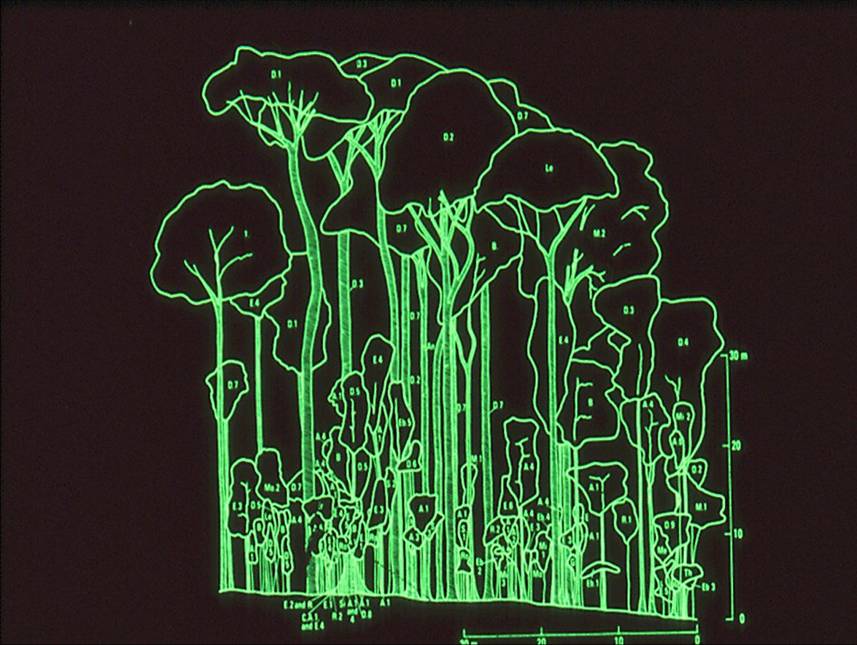
And to end this Introduction: a profile below of one of Borneo's great glories, now very largely gone. Lowland evergreen dipterocarp rain forest, Brunei. Mature phase forest except on the extreme right (from Ashton 1965, in Whitmore 1984a).
This forest peaks at 60m, which is common. Trees up to 80m occur occasionally. The tallest tree accurately measured in Borneo is an 88m monster near Tawau in Sabah. It is a very old specimen of Shorea faguetiana (Dipterocarpaceae). The lowest branch is at 40m! It has been climbed by Dr Kalsum Mohd Yusah of Universiti Malaysia Sabah.